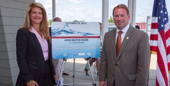
Neptune is participating in the High Watermark Initiative.
Click on the picture below for the High Watermark Initiative Launch video.
FEMA Flood Map Service Center
Find if your home is in a flood zone
The FEMA Flood Map Service Center (MSC) is the official public source for flood hazard information produced in support of the National Flood Insurance Program (NFIP). Use the MSC to find your official flood map, access a range of other flood hazard products, and take advantage of tools for better understanding flood risk.
FEMA flood maps are continually updated through a variety of processes. Effective information that you download or print from this site may change or become superseded by new maps over time. For additional information, please see the Flood Hazard Mapping Updates Overview Fact Sheet
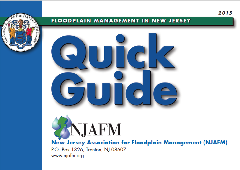
Click on the icon below for the 74 page Quick Guide on Floodplain Management
June 2015
The following is a revision to DCA Guidance on Electrical Meter Placement in a Designated Flood Zone.
Please review the documents below for detailed drawings of meter installation requirements and meter landings. The drawings have been updated to provide additional clarity regarding base flood elevation levels and the landing location.
Attached is the link to FirstEnergy website to view the entire document:https://www.firstenergycorp.com/service_requests/request-electrical-work/jcpl-meter-placement.html
JCP&L, A FirstEnergy Company
Customer Service: 1-800-544-4877

NATIONAL FLOOD INSURANCE PROGRAM AND IMPLEMENTATION OF THE HOMEOWNER FLOOD INSURANCE AFFORDABILTY ACT AND THE BIGGERT-WATERS FLOOD INSURANCE REFORM ACT
October 1, 2014
Dear Intergovernmental Partners:
Today, the Federal Emergency Management Agency’s (FEMA) National Flood Insurance Program (NFIP) is providing information on additional steps underway to implement changes to the program as a result of the 2012 and 2014 flood insurance reform legislation. The guidance on the changes being implemented will bring rates into compliance with the new laws beginning April 1, 2015.
The NFIP provides the opportunity for homeowners, renters, and business to purchase flood insurance for protection from flooding. FEMA also works with communities to update and develop flood maps to inform the community of their current flood risk. These actions allow community members to take important steps to prepare for flooding risk in their area.
On March 21, 2014, President Obama signed the Homeowner Flood Insurance Affordability Act (HFIAA) of 2014 into law. This law repeals and amends certain provisions of the Biggert-Waters Flood Insurance Reform Act of 2012 (Biggert-Waters) and the National Flood Insurance Act of 1968.
The new law slows some flood insurance rate increases and offers relief to some policyholders who experienced steep flood insurance premium increases in 2013 and early 2014.
The NFIP is in the process of implementing congressionally mandated reforms with the Program’s private sector, Write Your Own insurance company partners. Specifically, the flood insurance rate structure and business practices are being further revised to implement certain provisions of the legislations. Changes taking place in April 2015 include: annual rate increases for policies to support the gradual move to full risk rates; an increase in the Reserve Fund Assessment; implementation of an annual surcharge on all new and renewed policies; an additional deductible option; a one year preferred policy for policyholders who took part in a new flood map or revision; and an increase in the Federal Policy Fee.
The attached Backgrounder provides detailed information on the program changes taking place in April 1, 2015. Additional information can be found in the latest Bulletins provided to the NFIP’s private sector Write Your Own insurance partners at www.NFIPiService.com.
If you have any questions, please contact FEMA’s Intergovernmental Affairs Division at (202) 646-3444 or at FEMA-IGA@fema.dhs.gov.
FEMA’s mission is to support our citizens and first responders to ensure that as a nation we work together to build, sustain, and improve our capability to prepare for, protect against, respond to, recover from, and
mitigate all hazards.
Click here for file
Review, Update Your Insurance Policies
EATONTOWN, N.J. - September is National Preparedness Month, and the latter half of the year is an ideal time for people to review their insurance policies. Understanding the details of what specific policies cover and what the policyholder is responsible for after a disaster is important as both clients’ needs and insurance companies’ rules change.
Insurers’ decisions and legislative changes have the biggest effect on changes in policies. Consumers should make themselves aware of possible changes in these areas and know what to look for while reviewing their policies.
What’s Covered
The first check is the most obvious: the actual coverage. Policyholders should look at the specifics of which property is covered and the type of damage that is covered. Property owners should know that floods are not covered by standard insurance policies and that separate flood insurance is available. Flood insurance is required for homes and buildings located in federally designated high risk areas with federally backed mortgages, referred to as Special Flood Hazard Areas (SFHAs). Residents of communities that participate in the National Flood Insurance Program (NFIP) are automatically eligible to buy flood insurance. According to www.floodsmart.gov, mortgage lenders can also require property owners in moderate to low-risk areas to purchase flood insurance.
There are two types of flood insurance coverage: Building Property and Personal Property. Building Property covers the structure, electrical, plumbing, and heating and air conditioning systems. Personal Property, which is purchased separately, covers furniture, portable kitchen appliances, food freezers, laundry equipment, and service vehicles such as tractors.
What’s Not Covered
Policy exclusions describe coverage limits or how coverage can be purchased separately, if possible. Property owners should know that not only is flood insurance separate from property (homeowners) insurance, but that standard policies may not cover personal items damaged by flooding. In these cases, additional contents insurance can be purchased as an add-on at an additional cost. Some policies may include coverage, but set coverage limits that will pay only a percentage of the entire loss or a specific dollar amount.
The Federal Emergency Management Agency’s Standard Flood Insurance Program (SFIP) “only covers direct physical loss to structures by flooding,” FEMA officials said. The SFIP has very specific definitions of what a flood is and what it considers flood damage. “Earth movement” caused by flooding, such as a landslide, sinkholes and destabilization of land, is not covered by SFIP.
Structures that are elevated must be built at least to the minimum Base Flood Elevation (BFE) standards as determined by the Flood Insurance Rate Maps (FIRMs). There may be coverage limitations regarding personal property in areas below the lowest elevated floor of an elevated building.
Cost Impact of Biggert-Waters
The Biggert-Waters Flood Insurance Reform Act of 2012 extends and reforms the NFIP for five years by adjusting rate subsidies and premium rates. Approximately 20 percent of NFIP policies pay subsidized premiums, and the 5 percent of those policyholders with subsidized policies for non-primary residences and businesses will see a 25 percent annual increase immediately. A Reserve Fund assessment charge will be added to the 80 percent of policies that pay full-risk premiums. Un-elevated properties constructed in a SFHA before a community adopted its initial FIRMs will be affected most by rate changes.
In March 2014, the Consolidated Appropriations Act of 2014 and the Homeowner Flood Insurance Affordability Act (HFIAA) of 2014 were signed into law, lowering rate increases on some policies, preventing rate increases on others, and delaying the implementation of Section 207 of Biggert-Waters, which was to ensure that certain properties’ flood insurance rates reflected their full risk after a mapping change or update. HFIAA also repeals a portion of Biggert-Waters that eliminatedgrandfathering properties into lower risk classes. Many of the changes have not yet been implemented because the necessary new programs and procedures have not been established.
Other Conditions
The General Conditions section informs the consumer and the insurer of their responsibilities, including fraud, policy cancellation, subrogation (in this case, the insurer’s right to claim damages caused by a third party) and payment plans. Policies also have a section that offers guidance on the steps to take when damage or loss occurs. It includes notifying the insurer as soon as practically possible, notifying the police (if appropriate or necessary) and taking steps to protect property from further damage.
“FEMA’s top priority is to provide assistance to those in need as quickly as possible, while also meeting our requirements under the law,” FEMA press secretary Dan Watson said. “To do this, FEMA works with its private sector, write-your-own insurance (WYO) company partners who sell flood insurance under their own names and are responsible for the adjustment of their policy holders’ claims.”
Policyholders should speak with their insurance agent or representative if they have any questions about coverage.
For further information and direction, call the NFIP Call Center at 1-800-427-4661 or the NFIP Referral Center at 1-888-379-9531 . Comprehensive information about NFIP, Biggert-Waters, HFIAA and flood insurance in general can be found at the official NFIP website, www.floodsmart.gov
How to Pump Out a Flooded Basement
Click on the link above for directions on how to SAFELY pump out a flooded basement
| Instructions | Converting Existing Elevations |
| Block 1 to 399 | Block 400 to 450 |
| Block 451 to Block 499 | Block 502.01 Lot 1386 |
| Block 502.1 Lot 18 | |
| Block 557 Lot 1 | Flood Report |
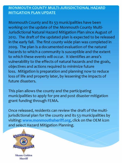
Click on the icon below for the County’s Hazard Mitigation Plan Updates

FEMA recently released this fact sheet on the Homeowners Flood Insurance Affordability Act. (June 25, 2014)
Click here for the fact sheet (two pages).
Most of which is found on this page can be found in one document, Public Outreach Program. Click on the title for the document.
Here are additional features of the program:
- Neptune Twp Shark River Area Storm Surge Map
- Neptune Twp/Ocean Grove Area Storm Surge Map
- Ordinance 13-11 (Flood Hazard Regulations)
- Ordinance 13-12
FEMA has released the new Preliminary Maps which are the next step to generating new FIRM (Flood Insurance Rate Maps). These maps can be utilized with the link tools provided for the general public to find their current Flood Elevation. This is an important tool to find your current flood zone and elevation. For flood elevations, these maps are the next step from the ABFE maps for flood insurance purposes. The Preliminary Maps are the basis for what the insurance companies will base your flood insurance on. Please be advised that these maps are “Preliminary” and are just being introduced. The public is encouraged to review them and the flood elevations with respect to your property
For Township purposes and elevating of structures the current ordinance relies on the ABFE maps and an elevation of 12 which includes the necessary freeboard. This will be in place until the new FIRM maps have been through comment period and review and are adopted as the official FIRM maps. At that time the Township will evaluate how this compares to the ABFE’s and the adopted elevation of 12 to the new FIRM maps and see if any revisions are necessary to the current ordinance.
The following links are very helpful for individuals to locate their property
http://www.fema.gov/view-your-
http://www.fema.gov/
-
Link to the National Weather Service Advanced Hydrologic Prediction Service gages. Note that the website provides up to three days of advanced warning of higher than usual water surface elevations.
Gages: USGS01407760 (Jumping Brook)
USGS 10407705 (Shark River)
Prepare Your Community, This online self assessment process is a tool to assist communities to reduce vulnerability and increase preparedness by linking planning, mitigation, and adaptation
Updated “Getting to Resilience” (click on title)
Getting to Resilience” is an online self-assessment developed to assist communities in reducing vulnerability and increase preparedness by linking planning, mitigation, and adaptation. Through this interactive process communities will learn how their preparedness can yield valuable points through voluntary programs like FEMA’s Community Rating System and Sustainable Jersey. The assessment process will also increase the community’s understanding of where future vulnerabilities should be addressed through hazard mitigation planning.
Developed to be used in association with NJFloodMapper.org , Getting to Resilience is the next step in communities planning for the risks associated with climate change and sea level rise. Together, these websites will help communities visualize their future risk and plan for that risk using their existing municipal planning tools.
Announcing the release of the Hurricane Sandy Mitigation Assessment Team Report!
The Federal Emergency Management Agency (FEMA) Building Science Branch would like to announce the release of FEMA P-942, Mitigation Assessment Team Report: Hurricane Sandy in New Jersey and New York. The Report documents observations made during field visits conducted by the Mitigation Assessment Team (MAT), specifically deployed to evaluate key building damage caused by Hurricane Sandy. It goes on to present the conclusions and recommendations derived from the field observations with regards to key engineering concepts, codes and standards, mitigation measures and considerations that can be used in the planning and recovery process to help minimize future damage to structures and their related utility systems.
The recommendations for disaster-resistant practices in hurricane-prone regions presented in the Report are applicable to planners; decision makers; designers; contractors; building officials; Federal, State, and local government officials; building owners and operators; emergency managers; and homeowners.
Observations, conclusions, and recommendations related to the following topics are included in the Report:
- Building Codes and Standards
- Flood Protective Measures
- Residential Construction
- Critical Facilities and Key Assets
- Mechanical, Electrical, and Plumbing Systems
FEMA P-942 can now be accessed and downloaded for free from the FEMA Library at http://www.fema.gov/media-
Should you have any questions or comments related to the Hurricane Sandy MAT Report, please contact John Ingargiola of the Building Science Branch (john.ingargiola@fema.dhs.gov) or the Building Science Helpline (866)- 927-2104 orFEMA-Buildingsciencehelp@fema.
Please visit the Building Science Branch homepage for additional multi-hazard mitigation information and resources. Be sure to also visit Hurricane Sandy – Building Science Activities & Resources.
Like other natural disasters, there are safety precautions that everyone can take to help protect themselves and their home in case of a flood. Floods can be the result of heavy rain, a water main break, or several other factors that are often out of the your control. If water does start to rise near your home, there are a few things that you can do to help protect your family and your house
Evacuation Routes
-
If you live in a low-lying or flood-prone area, you should familiarize yourself with the nearest flood evacuation route. These routes are designed by your community government to help everyone get out of the flood zone quickly in case of emergency. An official flood evacuation route should be marked with traffic signs. You can also get a copy of the evacuation route for your area through your local emergency services or government offices. Make sure that both you and your family are familiar with the route and have a meeting place designated out of the flood zone in case you are separated in an emergency situation.
CLICK HERE for evacuation route. Hit CTRL and the plus sign to make it larger. (CRTL +). Continue to hit the keys to enlarge it.
Drains
-
When the weather report shows a heavy or severe rain storm moving in your direction, take a few moments to go outside and make sure that your drainage ditches and storm drains are clear from debris. In a heavy storm these drainage areas can become clogged with debris, causing water to rise and potentially flood your home. Use a shovel or rake to clean these areas out, moving the debris off to where it will not easily wash back into the drain with the rain to make sure that water is allowed to run freely away from your home during the storm.
Flooded Areas
-
In the event a flood does occur, do not try to cross flooded areas. A good rule of thumb is that if the water is above your knees, do not try to cross it, either on foot or in a car. Maintain a safe distance, a minimum of six feet, away from running water, drains and ditches to prevent falling in. You should report any damaged electrical equipment, buildings and roadways to local emergency services immediately. Do not try to clear or repair damaged areas on your own. You should also make sure that both you and your family go to safety immediately. Do not linger to sight-see or attempt to help emergency crews unless asked to do so.
TAKE PRECAUTIONS BEFORE A FLOOD OCCURS1. Check your home for loose shingles and shutters, shaky chimneys, and other loose materials.Objects such lawn furniture, toys, garden tools, garbage cans, and garbage can covers cancause damage when carried by high winds. Secure tool sheds and playground sets. Storevaluablessuch as books, photographs, records and documents, etc. in areas of the home whichmight not be subject to flooding. Maintain a list of items that should be moved to higherground if water threatens to enter the home. Move hazardous materials to higher locationsincluding paints, oils, cleaning supplies, garden pesticides and fertilizers, gasoline and otherdangerous materials. Visit www.fema.gov/areyouready/flood.shtm.2. Maintain battery-powered equipment. A battery-powered radio could be your only source ofinformation and flashlights will be needed if utility services are interrupted. Flashlights areavailable that do not require batteries. Take extreme care in the use of candles to avoid fires.3. Cable Phone Service: If your plan service is provided by your cable company, it will beinterrupted if the power goes out.4. Signup for the Emergency Notification System, (Reverse 9-1-1) a service that allows theOffice of Emergency Management to contact registered phones with critical and timelyinformation. You can register your home, cell phones and office phones. You can sign up forthe Emergency Notification System at https://shoreareaens.onthealert.com/Terms/Index/?ReturnUrl=%2f5. Learn the location of the home’s water supply pipeline valves and shutoff, master electricalswitches, and gas shutoff valves. Do not wait until areas of your home become inaccessiblebefore deciding to shut off these services. All family members should know how to accessthese utilities.6. Tune to the local television stations for the latest weather advisories and special instructionsfrom your local government. Avoid accepting and passing on unverified information.7. Plan your evacuation route in advance. Keep your cars fueled should evacuation be necessary.Service stations may be inoperable in the event of electrical outages. Move your cars to higherground for protection.8. Store drinking water in clean bathtubs, jugs, bottles, and cooking utensils in the event that themunicipal water system is affected by the storm.9. Board up windows, or protect them with storm shutter or rope. Danger to small windows ismainly from wind-driven debris. Larger windows may be broken by wind pressure. Tapemay not keep a window from breaking, but it is an effective means of protection from flyingglass.10. Pets are not allowed in temporary shelters. During a flood evacuation, they will not beaccepted at evacuation shelters or allowed in the rescue vehicles or boats. Plan ahead for careand protection of your pets; they are your responsibility.11. If possible, seal off all sanitary sewer access points; such as sinks, toilets, floor drains, washbasins which may be below flood water levels.EMERGENCY WARNING TERMS:A flood or hurricane “Watch” will be in effect if flooding or a hurricane is expected. Flooding is apossibility, not a certainty.A flood or hurricane “Warning” becomes effective when flooding is imminent.As the storm progresses, a flood or hurricane “Emergency” may be declared.School closing and early dismissal policies are determined by the Board of Education based on theparticular situation and disseminated using their Emergency Notification System.Remain indoors if you choose to remain at home.Keep children of all ages away from river banks and out of the floodwaters. Flood waters are usuallycontaminated. Do not drive unless it is essential. Secure all loose objects outside the home, such asoutdoor furniture and toys. Relocate and/or move valuable and furniture (if possible) to higher areas inyour home. Move your automobiles to high ground if flood waters are a threat your area.WHEN YOU EVACUATE YOUR RESIDENCE:1. Shut off the gas, electric and water supplies at the main shut off in the house. Leave thebreaker on for the sump pump if you have one.2. Open basement windows to make provisions for water to enter the lower level of the house.Water will also enter through a sump drain. The presence of water helps support the floorsand foundation walls from outside pressure and often prevents collapse.3. Keep your personal ID on your person at all times during the event. Take important insurancepolicy information with phone numbers along with you in a plastic bag.4. Temporary emergency shelter locations will be announced prior to or during the flood event.If you leave your home and do not need public shelters, you still need to register at thedesignated shelter locations so your whereabouts will be known.5. Pets will not be accepted at evacuation shelters or allowed in the rescue vehicles or boats.Take steps to help your pets before an evacuation is imminent.6. Emergency Personnel at location evacuation shelters will keep you informed of conditions andwill indicate when it is safe to return home. Do not attempt to return to your home withoutclearance; you may hamper or interfere with rescue work. Temporary entry into stormaffected areas, until these areas are declared safe, maybe limited; for example, to a singlemember of a family with proper identification.7. Never drive into water covering the road as depth is difficult to determine from the driver’sseat and the road may be washed out. More than half of all people killed in floods arethose in vehicles. According to the National Weather Service, it only takes 18 inches of waterto lift your car or SUV. Once your vehicle becomes buoyant: the water will easily push itsideways. Most vehicles will then tend to roll over, trapping those inside and washing themdownstream. If you are driving and the road has water over it, you need to remember thissimple saying: “Turn Around - Don’t Drown”. Never drive on a road with water covering itand never drive around barriers blocking a flooded road or it just may cost you your life.
Tools & Resources: FloodSmart.gov
The official site of National Flood Insurance Program